Mystery at the Museum: Beeler Canyon

I am still working on the new promotion at Geocaching.com called Mystery at the Museum (MatM), a month long game-within-the-game in which geocachers can earn several cool, new badges. For details, click (here). For the details of finding my first clue, click here.

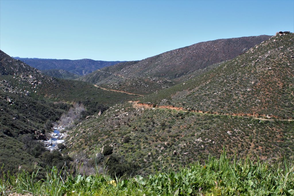
After my less than spectacular search at the 4:10 cache, I was determined to prove to the virtual detective that I was up for this case. Combing through the case files that she gave me and making good use of the filters on the geocaching.com website, I surmised that Beeler Canyon might be a good spot to initiate my search for clues. Beeler Canyon is kind of an odd place, sandwiched between the Stonebridge neighborhood in Scripps Ranch and the back side of the technology park near Costco. The beginning of the road has some nice homes, then there is more of a farm-like area, and then it opens up into an empty canyon. The Vulcan Materials company owns some of the land, and the area also serves as an escape route for Stonebridge, with fire roads dropping steeply down to the canyon. Towards the end of Beeler Canyon road are some nice trailheads into Sycamore Canyon.

The door to the hobbit house…

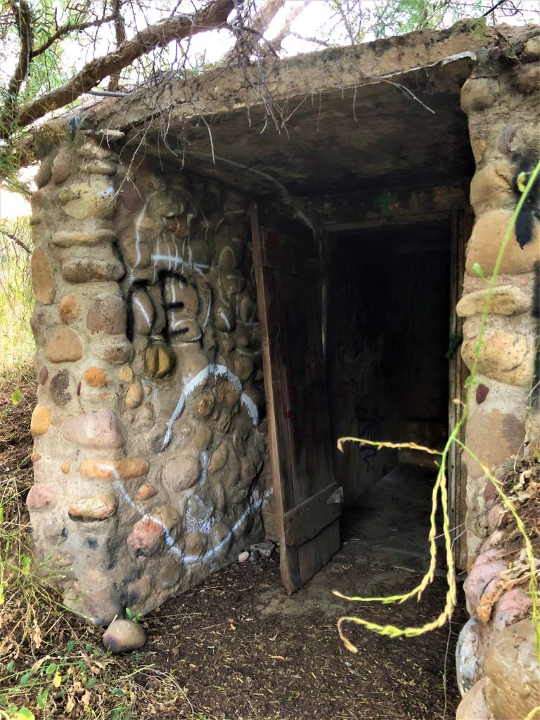
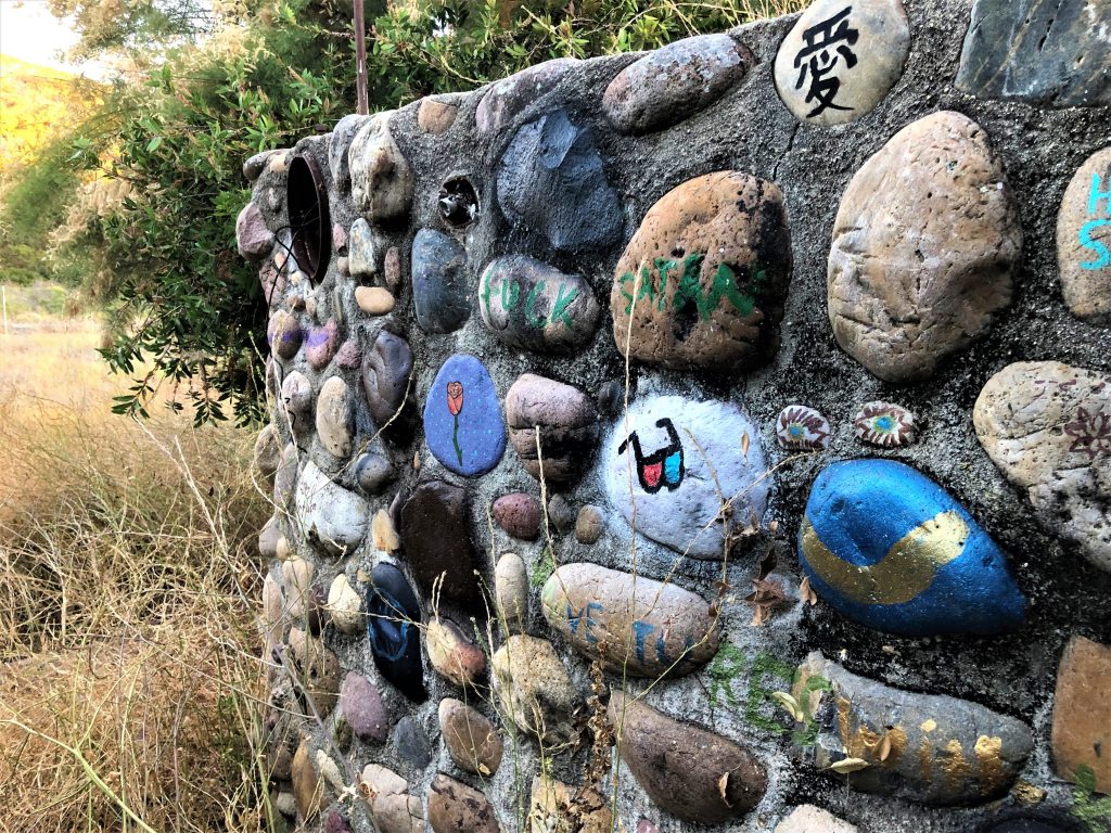
Two of the three caches here that had clues were your garden variety park-n-grabs, but one (Beeler Road Rock Ruins, GC5YPPF) was located in a remarkable place. GZ was about 100 feet off the road, in a copse of trees within a fenced enclosure with only three sides. There was ample evidence of nefarious activity in the area, including broken beer bottles, drug paraphernalia, and some old clothes. I approached the trees carefully, listening for teens and watching for rattlers, and then the doorway came into view. The place was well hidden by the thick, dead brush and the overgrown trees. The doorway reminded me of an elven home out of Lord of the Rings. In fact, the whole building, or at least what’s left of it, was very otherworldly. The walls were imbedded with large stones and beer bottles, all of which seemed to have been put there on purpose. There was the usual smattering of graffiti, but some of the rocks were actually painted quite nicely. After a bit of exploring, I failed to find the stolen jewels, dead bodies, or any angsty teens. I did manage to find the cache pretty quickly and given the virtually infinite number of potential hiding spots at this site, I’m hoping for a virtual brownie point from the virtual detective. Anyhow, between the three Beeler Canyon caches, I collected one fingerprint and TWO shadows! Dun dun daaa! So I just need one more fingerprint and two footprints to move onto the next level. So I made good progress towards solving the MatM case and had a cool little adventure.

A blend of art and graffiti on the stone walls

Black Canyon (Ramona, CA)

            With all of San Diego in a buzz about the recent Superbloom and the billions of butterflies migrating through the area, I thought I would take a drive out past Ramona and catch these once in a decade phenomena. Sadly, I saw neither out there. What I did find, however, was a very cool part of San Pasqual valley known as Black Canyon.

            Magnolia Avenue winds its way out of Ramona and through pastoral farms dotted with the occasional vineyard. Civilization comes to a rather abrupt end, as does the pavement. Black Canyon road continues as a narrow, dusty, pothole-laden trek around some very blind corners (better honk first). At a couple of spots, the road dropped off precipitously into gullies that seemed a popular dumping ground for various items. I shudder to think what kind of crap is hidden out of sight in the brush fifty feet below the road.

            The geocaching here is decent for a pseudo-powertrail, but a few precautions are in order. I made the drive in my passenger car (an Infiniti) and I never really felt too afraid of damaging the car or getting stuck in the sand. However, if it has recently been raining I would think a four wheel drive might be safer. Which brings me to the next point: cell service. My carrier, who will remain nameless, was pretty spotty out here and there were many stretches where I had no cell service at all. There was an occasional car on the road, but from a safety perspective, it is pretty desolate and so some preparation may be prudent. From the geocaching perspective, downloading the caches for offline use is essential.

The first few miles was very scenic, with a rugged, colorful, Mars-like landscape split by the lush, riparian boundaries of Santa Ysabel creek. There are also a number of good caches along this stretch. There are a few in the 4:10 series (for example GC6YB2M) because as KikbakJack would say, “it’s always 4:10 to somewhere”. If you haven’t done this series, I recommend it. Once I got the hang of what I was looking for, they became really fun. Another notable cache is GC2V2KW, also by KikbakJack. It’s a classic ammo can at a spot with a nice view.

One of the big highlights of the trip was at the intersection of Black Canyon road and Sutherland Dam road. Although a modern, surprisingly nice bridge crosses the creek here, the original Black Canyon bridge has been left behind. Built in 1913, it is one of the last surviving examples of what is known as the “Thomas System Bridge” or the “three-hinge arch”. These bridges were built by the Thomas and Post company (Los Angeles) and were innovative in two ways. Unlike most bridges, which are built at the site, the arch ribs and spandrel columns of the Thomas System were precast and then assembled at the site.  Three hinges (basically connection points designed to absorb movements due to stresses, ground movements, and temperature changes) were made, two at each foundation footer, and one at the top of the arch.  The hinge at the arch was unusual for the time, and likely made the shipment of the precast pieces easier to manage.

As I stood on this lonely bridge in the middle of nowhere, I couldn’t help but wonder what kind of shenanigans had occurred here. Over a century of teen parties for sure, probably a fatal accident or two, and there was even a body dumped from here in 1977 (David Hargis, killed by his wife and thrown over the bridge). It was a little creepy in the daytime, so if anyone has heard some good ghost stories about the area, I’d love to hear about them! Sadly, the geocache hidden here (GC2V2RE) was missing, but visiting this bridge was the highlight of the trip.

I did not cross the shiny new bridge, but opted to head up Sutherland Dam road to see the reservoir. The views here did not disappoint either! The dam has a very unusual shape and is quite beautiful, with its sandstone-like coloration. Although construction began in 1927, money issues and political squabbles (apparently this is not just a modern-day issue) delayed completion until 1954. Interestingly, one of the stories about why it was named after Sutherland comes from the book “On Memory’s Back Trail” by Darrell Beck. In the book, Beck discusses a story about how Sutherland helped out a civil engineer named Post, who wound up cold and drenched at Sutherland’s home while surveying for the dam. Could this be the same Post from the Thomas and Post company in LA who built the Black Canyon Bridge? Geocaches in the area (particularlyGC794G1 and GC1ZY2W) offer nice views of the dam and Lake Sutherland. I hit a few more caches along Sutherland Dam road and it eventually led me back to SR 78. This was a wonderful little loop, containing many fine geocaches, some gorgeous views, and some truly unique California history.